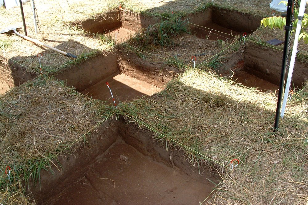
After much hard work, the crew are now well into their final week at the field school. In the field, students are finishing up their units. On Monday, at least four units were completely finished, with piece plotting and elevation measurements completed for the bottom of the level. In two of the units, possible post mold features were also excavated - the fill from both features will be analyzed in the lab at a later time.
Out of the field, students have been very busy putting their poster presentations together for a small poster presentation at the Qualla boundary (Eastern Band Cherokee) community center on Thursday just for us. As of this evening, Dr. Jeb Card has submitted everyone's posters to a local photocopy center, and all should be printed and ready within 24 hours. All of the posters look fantastic - the students should all be very proud of their hard work.
Today's activities were summed up nicely by Liz's post below. Hopefully for tomorrow's blog we will have a few new pics from the field to show off to everyone, as it will be the final full excavation day for students for the season (all other days in the field will be for clean-up).
Wednesday, June 23, 2010
Tuesday, June 22, 2010
Having fun water screening
.JPG)
The first half of the day was devoted to finishing up poster presentations for Cherokee on Thursday. These presentations are important in showing what information about the material culture and the landscape in the Greene County, Tennessee.
After lunch, rather than going to the site to work, we did some more water screening up at the Ernest residence. This time the weather was better suited for it; sunny and warm. Since it was warm we all decided to have a bit of fun and wear bikini tops. We split into two groups, each doing separate units so that we could get through the soil bags that have been collected. What we did was each unit and lot number was washed on fine mesh screen to find materials that weren’t found on the dry screen. All the material that did not go through the screen was collected along with the tag for the bag onto trays so that later sorting can be done. The soil bag was washed as well so that all the soil is off it.

Sunday, June 20, 2010
Day 15 - Visiting the Berry site
On Friday we visited the Berry site, a long term archaeological research site near Morganton, North Carolina. The current project is co-directed by Dr. Christopher Rodning of Tulane University in New Orleans and Dr. David Moore of Warren Wilson College.
Dr. Rodning was kind enough to give us a tour and explain the significance of the site. A large Native American town was located at the site from 1400 to 1600 A.D. Archaeological investigation at the Berry site focuses on the Spanish contact period, when the town was known as Joara, and visited by Hernando de Soto in 1540, and Juan Pardo 30 years later. A fort was built at the site by Pardo in 1567 and lasted for 18 months before it was abandoned due to conflict with the Native people.
The Berry project is impressive in both its large scale and its community atmosphere. There were at least a dozen people working, and they ranged in age from 18 to 50. They worked as a harmonious team, with some shovel skimming the surface of units, while others were sifting the earth through screens, carting the dirt away in wheelbarrows and washing artifacts. They took their morning break during our visit, and distributed popsicles and ice cream sandwiches to all workers and guests as a cool treat to beat the heat.

As our group looks on, Dr. Rodning climbed up a latter to photograph large features from above.

Our group was able to examine the recently unearthed and washed artifacts as they dried in the screens.
Following our visit to the Berry site we stopped for lunch and then traveled back to Tennessee to continue our work.
Why Ceramics?

Archaeologists spend a lot of our time discussing ceramics but it is not always clear to those listening why that may be such an important part of our research. On our site this year we have found a variety of ceramics some smaller than a penny and some as large as our fists but each of these sherds can provide information about the people who lived and worked on this landscape. There are a variety of reasons that ceramics are vital to archaeology including but not limited to their potential for social and household interpretations.
Each time you pick up a ceramic sherd you can potentially learn about the type of vessel (form), the purpose of that vessel, what kinds of decorations graced the body and how this vessel was made. These types of information can help archaeologists learn about the household and how it functions. One important piece of information that ceramics can provide is information on gender roles within a household. In Cherokee society women held much of the control over ceramics because they created the vessels. Theda Perdue (1998) in her book Cherokee Women: Gender and Culture Change, 1700-1835, describes the vessels made by women as pitchers, bowls, dishes, basins and platters. Most of the vessels we have examined in our lab time and in the field have been bowls of varying sizes.
Ceramic sherds can also provides us with information about how vessels are made, for example temper or coiled versus hand formed. We have learned quite a bit this summer about the different types of temper that are common in ceramics for our region. We have had the opportunity to examine shell tempering, grit tempering and sand tempering. Looking at all of these types of tempering has been interesting because it gives us a better idea of how these pots were made and where the materials may have been coming from.
Ceramics are also vital to archaeology because of their presence in the archaeological record. Ceramics simply preserve well in most contexts and are relatively fragile during use. This seemingly contradictory fact makes ceramics both easily destructible, getting deposited in the archaeological record frequently, and well preserved. This good preservation is great for archaeologists because it provides us with a wealth of information about households and social relations within a community or even a region.
Thursday, June 17, 2010
Day 13 and 14 - Getting to the Bottom of Things
The last couple of days in the field have proven to be rather eventful - students have finally reached the bottom of the plow zone in their units, and have descended onto the cultural layer that is the focal point of this archaeological investigation. Although this layer is a sort of "living surface" with culturally sterile soil not far below, this is the layer where features such as post molds and structural foundations are going to turn up and is thus vitally important. Students will from this point onward trowel very carefully and deliberately through their levels.
Most units have shown a mottled soil still consisting of some plow zone soil. Some even have distinct trenches cut into the cultural layer filled with plow zone soil - a clear sign of a plow scar that long ago dug into that layer. One unit, however (20 South 22 East), does appear to have a post mold. It is nothing like the numerous post molds found in last years 20 South 15 East (which we uncovered again over the past couple of days for reanalysis and point of comparison with other units), but shows promise that an extensive number of structures once existed at this site.
 The post mold in unit 20 South 22 East
Not surprisingly, artifact finds are proving to be more and more interesting. Some of the highlights include a couple of lithic cores, a few large pottery sherds with surface decoration, and one large piece of iron seen below.
 The mysterious piece of iron.
 The mysterious piece of iron.
Other than its material, we are unsure what sort of object it may have been. Based on its flat shape, we have speculated that it may have been attached to a wooden surface. The likelyhood of proper identification remains to be seen.
Most decorated pot sherds found over the last few days have either been check stamped or cord marked, both of which are surface treatment styles common to the Woodland Period of East Tennessee, but not necessarily unheard of in Mississippian and/or historical contexts.
 A check stamped sherd, in situ.
One sherd uncovered during the last couple of days, however, appears to be a rectilinear complicated stamped. Complicated stamped surface treatments are typical of Mississippian cultures found throughout what is today Georgia, South Carolina, and parts of northern Florida, North Carolina, Alabama, and Tennessee. This stylistic attribute is definitive of Mississippian and historic cultural sequences in western North Carolina and upper East Tennessee.


Though badly damaged in the plowzone, this sherd above shows the telltale stamped lines and corners typical of a rectilinear complicated stamp motif.
 One of our field school students, Katie, proudly showing off the sherd, which was found in her unit.
The next few days of field excavation will only reveal more exciting artifacts and features, as students carefully excavate through the undisturbed cultural layer in their respective units. Tomorrow, however, the crew will be taking a field trip to the Berry site in North Carolina, where excavations are currently underway. Come Monday, students will be back to work for their final week of field work. Stay tuned to this blog for more updates!
Day 12 - "Snakes... Why Did it Have to be Snakes?"
What would an archaeology blog be without at least one Indiana Jones reference? Albeit an obscure one... The title for today's entry was inspired by our encounter with this impressive-sized black racer snake below:
 Is it turning its nose up at us?
 Is it turning its nose up at us?
The snake eyed us suspiciously for a bit, and after it decided we were (mostly) harmless, lived up to its name and made a dash for the tree line.
The snake was not the only animal encounter today of note. The crew was also visited by some rather bold butterflies, who insisted on landing on us for long periods of time, presumably to consume salt off of our sweaty clothes.
 This butterfly sat on Dr. Jeb Card for quite a long time.

We will continue to post more interesting finds as they are unearthed.
The snake was not the only animal encounter today of note. The crew was also visited by some rather bold butterflies, who insisted on landing on us for long periods of time, presumably to consume salt off of our sweaty clothes.
 This butterfly sat on Dr. Jeb Card for quite a long time.
Animal encounters aside, today was an unusual field day. The rumbling of thunder early in the morning set us packing out of the field before 11am, only to have us return again after 2pm to work until well after 4pm. Despite this peculiar schedule, and the by-now-to-be-expected heat and humidity, excavation still progressed nicely.
Students, especially those in the southern units, have begun encountering increasingly larger and more impressive artifacts - particularly lithic flakes. Some of the nicer samples from today can be seen below:


We also found our first piece of unaltered bone of the season today (we found pieces of calcined bone late last week). It looks to be a shaft fragment of a long bone of a cow or deer, thought cow is probably the likely candidate as we are excavating near a pasture.


We will continue to post more interesting finds as they are unearthed.
Tuesday, June 15, 2010
Day 11 - Back to the Field

The students returned to the field today to start week 2 of excavating; and if today is any indicator, it will be a very productive week at that. Unfortunately, it was another very hot and humid day in the field, though the occasional cloud and cool breeze helped to break it up. The tents also helped tremendously, though they are indeed a pain to set up and take down - sometimes literally, if someone manages to get their hand caught in one of the joints in the process. This has happened several times already.
This week we have a few new fresh faces helping us out in the field: one new grad student, and two representatives from the Eastern Band of the Cherokee Indians. All three individuals will only be with us this week, but we certainly appreciate them being here to help with field work while they are around. Their presence today was already a tremendous boost to an already very productive field crew.
As for excavating itself, many students are now digging to as low as 20 to 25 centimeters below datum in their units. We should be expecting students to be getting to the bottom of the plow zone and on to the living surface very soon. In Jenna's unit 20 South 22 East, some particularly large-sized pieces of lithic debitage have started to show up. Although still in the plow zone and therefore in a disturbed context, the lithics appear to be concentrated in a particular area of the unit. We will be keeping an eye on this potential "feature" over the next couple of days. Some photos of the flakes, some still in situ, can be seen below:


Some of our "new recruits" for the week also had the opportunity to measure out new 1X1 meter square units around last year's unit 20 South 15 East (the one with post holes). Once students begin finishing up their old units around last year's 20 South 21 East, they will begin breaking ground again at these newly measured ones.
The day finished up very nicely for everyone, and with great timing: we managed to pack up and head out shortly before an afternoon thunderstorm hit the area. Though things are going well, the students and the staff alike would all certainly appreciate a few cooler and/or less humid days for the remainder of the week. From the look of weather forcasts, we may not be so fortunate...
Monday, June 14, 2010
Day 11 - Welcome to the Lab
We're shifting into high gear with lab analysis, as the students work to analyze some of the materials (currently ceramics) collected at the site. So I decided (that's me in the video below, the lab director) to give a brief intro to our laboratory. I hope to show some of the students' analysis work, and perhaps some of their conclusions, at a future date.
Friday, June 11, 2010
Day 10 - Crazy from the Heat
After two days of deluge, today's foray into the field was met with extreme heat and humidity. Despite this, and the usual exhaustion and exasperation such excavation situations bring, the work day proved to be very interesting. Although hot and humid, the ground and equipment were dry, and therefore we were able to devote a normal full day to field work. The day started with taking a Munsell reading of yesterday's levels, and then students began troweling and shovel-skimming their way down to the bottom of their level 3's. As the morning progressed, some of the students got up-close and personal with some of the local wildlife:

We have encountered about three spiders of roughly this size in the field so far this season. Aside from obvious examples such as tarantulas, these are some of the largest spiders many of us have ever seen. Let us hope "human" isn't on this critter's menu.
Despite the uncomfortable weather, work went on as usual. Here are a few notable action shots of the day:
 Working hard sifting dirt.
 This one goes to Eleven
(video clip in case you aren't familiar with the phrase)

We have encountered about three spiders of roughly this size in the field so far this season. Aside from obvious examples such as tarantulas, these are some of the largest spiders many of us have ever seen. Let us hope "human" isn't on this critter's menu.
Despite the uncomfortable weather, work went on as usual. Here are a few notable action shots of the day:
 Working hard sifting dirt.
 This one goes to Eleven
 (video clip in case you aren't familiar with the phrase)
Today's excavations produced a particularly interesting find: a very nicely-preserved check-stamped ceramic sherd.

Check-stamped ceramics are common during the Woodland period of East Tennessee, but are also not unusual in Mississippian or historic contexts as well. Many of the students agreed that this particular specimen was the nicest preserved one they had seen - possibly even nicer than other check-stamped sherds in our type collection!
 One of the students showing off her spectacular find of the day: the check-stamped sherd.
Many other students were proud of their finds this week as well. Here are a few more pictures of students showing off their finds from earlier in the week:
 A ceramic sherd.
 Another ceramic sherd.
 A ceramic sherd.
 Another ceramic sherd.
As the day progressed, the weather got increasingly oppressive. Thankfully, the owner of the land where the Yellow House site is located came to our rescue and brought us some tents to work under for the remainder of the afternoon. They were a pain to set up and take down, but they did provide a reprieve from the glaring sun for awhile.
 Working in luxury.
As the afternoon progressed and the students continued digging, measuring, sifting, and bagging; Dr. Jeb Card and Burton Smith began opening up last year's unit 20S 15E, which was the unit with the post holes. We hope to have the living floor of this unit reopened for analysis and visual reference by early next week.
At the end of the day, most students had finished or had come close to finishing their level 3's. Between downpours, mud, and oven-hot conditions, the students persevered without complaint this week. With the arrival of the weekend, they get a much-needed break, and will begin again fresh on Monday.
Day 9- Another Wet Day
Mother Nature again determined the course of fieldwork for the day. After attempting to reach the site in the rain, it was decided to begin water screening at a residence about one mile away from the site. In the field, all sediments removed from the excavation units are sifted through ¼ inch mesh screen. All of the dirt that falls through the screens is then collected, bagged, and labeled with excavation unit information for water screening. The falling rain may not help very much during excavation, but during water screening, it is a welcomed aide.
Water screening recovers much smaller artifacts than dry screening alone. As the name implies, water screening uses water to help push sediments through 1/16 inch window screen. Small lithic and ceramic artifacts that may have passed through the ¼ inch mesh screen during dry screening are often able to be recovered during water screening. Water screening also allows for the recovery of plant remains, such as seeds and shells, which can be studied by ethnoarchaeobotanists to shed light on the diets of the inhabitants of the site.
After morning break, the skies began to clear so the crew walked to the site rather than risk getting the van stuck in the mud. Excavations continued on into the afternoon, with many students able to close out another level.
Day 9 - Wet Day, Wet Screening
Here are a few images for Day 9, to compliment Jenna's post above.

 Water-screening
 The crew, working during a rare moment of dryness.

 Water-screening
  The crew, working during a rare moment of dryness.
Everyone in the crew will keep their collective fingers crossed that things start to dry out soon. Despite the rain, progress is still being made.
An interesting note: Jessica, one of the students on the dig, discovered that one of the larger lithic pieces so far recovered from this season may in fact be a broken prismatic blade - a type common to this area during the Woodland Period. Here is an image of the blade in question:

An interesting note: Jessica, one of the students on the dig, discovered that one of the larger lithic pieces so far recovered from this season may in fact be a broken prismatic blade - a type common to this area during the Woodland Period. Here is an image of the blade in question:

Thursday, June 10, 2010
Day 8 - Blame it on the Rain
by B. Smith
Unfortunately, field work was somewhat thwarted due to on-again-off-again (but mostly on-again) heavy downpours. The rest of the week does not look too promising either, with a 40% chance of rain up through Friday. Today, however, was especially rough - there were even some flash flood warnings for nearby towns. The executive decision was made to park our van at the top of the hill away from the site, so that we would have high enough ground to drive out of if the ground got too saturated. We wanted to avoid getting quagmired at all costs. The weather seemed to enjoy tormenting us: at least twice it would rain heavily, only to subside right about the time we managed to pack up all of our stuff into the van.
 The van on the hill, during a rare dry moment.
Despite the rain, we were still able to accomplish some things in the field. Primarily, all students were able to check the soil coloration of the bottom of their unit via the Munsell color chart. Some were even able to make considerable headway into their next excavation level.
 Using the Munsell color chart.
We ultimately had to leave early, due to concerns over wet equipment and soaked units, but students were able to make up for the lost time with more time spent in the lab with Dr. Jeb Card. Even with today's setback, progress in the field is still coming along very nicely.
Wednesday, June 9, 2010
Tuesday, June 8, 2010
Day 6 and 7 - Groundbreaking! (Excavation Begins)

By B. Smith
After a week of surveying and learning about some of the background history and prehistory of northeastern Tennessee, the students were finally ready to start breaking ground on the Yellow Cabin Site. Excavations this year will focus primarily on the area around last year's Operation 1, unit number 20 South 21 East, which produced some curious features filled with charcoal. On Monday the students started out helping to measure out 2X2 meter grids, which were subsequently subdivided into 1X1 meter grids to be converted into test units.
 Measuring out a grid, and double-checking appropriate point distances with the hypotenuse.
 Altogether, six units were parceled out for excavation - one per student, and an additional unit to be worked on by both lab director Dr. Jeb Card, and field director Burton Smith. After the students received their designated 1X1 test units, they began the arduous task of clearing off excess brush and tall grass off of the surface.
 Clearing the surface.
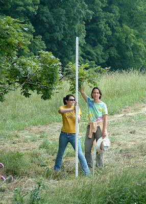
Once the units were all reasonably cleared, the students assisted in shooting in elevation points in their units with the total station.
 Holding the stadia rod and prism in place.
By Tuesday morning, students were ready to establish their datums and start digging down 5 centimeters to the bottom of their first level. Since the surface soil was plow zone and choked with thick roots, this task was accomplished through the use of shovels for skimming, with some troweling to smooth out the floor. The students struggled through the roots, but all managed to finish their first level by the end of the day. They even managed to bag, pack up, and haul away all of the dry-screened soil from their individual units, to be water-screened at a later date.
 All students were able to finish their levels before the end of the day.
The plow zone at the Yellow House Site represents a completely disturbed context that can extend below the surface to about 20 or 25 centimeters. In spite of this decontextualized soil horizon, artifacts found here can still give clues to the nature of cultural activity preserved below the plow zone line. Students collectively uncovered several artifacts - sand or grit-tempered ceramic sherds, lithic flakes made from local chert, fire-cracked rocks, as well as the occasional artifact of more recent periods (plastic). Not bad for the first day!

 Two examples of some of our first finds of the season - a couple of small ceramic sherds.
The students definitely deserve praise - they've worked very hard and diligently, and have been very productive with the time allotted for excavating. With any luck, we may yet be able to finish these first sets of units and open up new units around last year's Operation 5, unit number 20 South 15 East, which produced a series of small post holes.
Monday, June 7, 2010
Day 5 - Cherokee, North Carolina

By Project Director, Dr. Kathryn Sampeck
We ended our week of learning about the landscape by traveling to Cherokee, North Carolina to meet with the Eastern Band of the Cherokee Indians (ECBI) Tribal Historic Preservation officers and to explore different museums in Cherokee. Our project has strong ties with the ECBI and benefits from active collaboration and participation of members of the ECBI.
The route from Greeneville, Tennessee to Cherokee features has stunning scenery in the Appalachian Mountains, passing through the Cherokee National Forest and the Pisgah National Forest. Even today’s highways have to negotiate steep twists and bends before descending into the Asheville Basin. Nevertheless, the early historic material culture from Washington and Greene Counties show strong similarities to these parts of today’s North Carolina, so these mountains were not an impassable barrier in the past.
We started our visit with a tour of the sacred site of Kituwah. ECBI archaeologist Russ Townsend explained that all Cherokee regard Kituwah as the mother place, where the first Cherokee council fire burned and that Kituwah has always been important in Cherokee life. ECBI historian Tyler Howe and archaeologist Yolanda Saunooke showed field school students different parts of the site, including the medicine place near the Tuckasegee River.
We next visited the living history museum of the Oconaluftee village. There we saw craftworkers producing traditional Cherokee material culture, including projectile points, wood carvings, baskets, and belts. Guides explained Cherokee political and social organization in detail as part of their tour. In the mid-afternoon, we attended a demonstration of several social dances in the village dance grounds. Ocunaluftee has model homes typical of different time periods, allowing us to see changes in architecture from the 1540s to the nineteenth century. Being able to step inside a sweat lodge or an 1830s house gives us a better sense of archaeological traces of the past.

Potter's tools from Oconauftee include a paddle for decorative marking and shells for incising and scraping.
After the village, we ended our visiting day in the Museum of the Cherokee Indian. Exhibits cover each major period of Cherokee history, from the earliest Paleoindians and their stone tools to Cherokee soldiers in World War II. The museum is notable for its detailed presentation of the historic period, especially the eighteenth and nineteenth centuries. This week the students have been studying Mooney’s Myths of the Cherokee, and a number of narratives collected in that work were vividly depicted and recounted at the museum. Regarding material culture, whole ceramic vessels. much like the small fragments we are studying in the project lab, were on display, as well as more recent pieces. The whole day gave us many perspectives on the place, history, and peoples we are studying.
 Early spear points
Printed in the Cherokee script
We returned to Tennessee on a different route, this time through the Great Smoky Mountains National Park. Rain soon drenched the roads and forests, but after a short while the sky brightened and a shimmering rainbow shone before us, the perfect end to our day.

Friday, June 4, 2010
Day 4 - Mapping

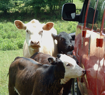
After two days of regional survey, we narrowed our activities to the site which will be the focus of the rest of the field school. By no means are we alone at the site. The immediate environs are home to dozens of cattle who insist on licking (for salt) and other wise crowding around the project van.
Today the students learned several elements and steps in creating a site map. These methods are illustrated in the video below
- Contour walking. Utilizing a GPS, the students followed the contours of a nearby hill, to experience and understand elevations on topographic maps.
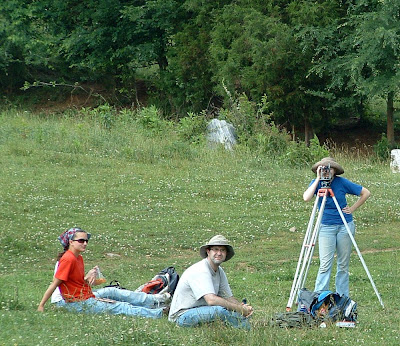
- Collecting topographic data. All of the students took measurements from various points in and around the site, using a traditional surveyor's transit. Utilizing such equipment and collecting and transforming the data by hand, rather than with a computerized total station, teaches the methodological principles behind mapping. As the season progresses, students will also utilize the computerized total station.
- Mapping topographic data. After a good day in the hot sun, the students returned to the lab, and created a topographic map using the data they collected earlier.

Today the students learned several elements and steps in creating a site map. These methods are illustrated in the video below
- Contour walking. Utilizing a GPS, the students followed the contours of a nearby hill, to experience and understand elevations on topographic maps.
- Collecting topographic data. All of the students took measurements from various points in and around the site, using a traditional surveyor's transit. Utilizing such equipment and collecting and transforming the data by hand, rather than with a computerized total station, teaches the methodological principles behind mapping. As the season progresses, students will also utilize the computerized total station.


- Mapping topographic data. After a good day in the hot sun, the students returned to the lab, and created a topographic map using the data they collected earlier.
Subscribe to:
Comments (Atom)