Wednesday, June 29, 2011

Features!

At the start of the day some of the units were already down to the natural soil layer, while others still had to keep digging to get down to theirs due to there being more sediment from flooding over the years. Those of us that were already down to the natural soil began our day in the field by defining our features and mapping them to scale on graph paper. After we finished that we got to start carefully digging up our features and bagging up the dirt for flotation to recover small things like organic material.


Below: Steve Scheflow digging up a post mold and bagging the dirt


Since we were digging much smaller areas and had to be careful not to damage artifacts and to keep the integrity of the shape of the feature we ditched our trowels and started using spoons and dental tools.


Below: Laura Volz works on exposing a pottery sherd with a dental pic


Some of our features had nothing in them, some had a few artifacts, while others (like the above photo) had an abundance of artifacts, including shell (marine & freshwater), pottery sherds, chert, bone and a bone bead. For the features that contain many artifacts we had to dig around them and leave them where were naturally deposited (in situ) in order to see the way they are arranged to help us possibly figure out why they are positioned the way they are. Then once the exposed artifacts have been photographed in situ they can be collected.


Below: Two post molds and a feature with half of the artifacts in situ


As we continue to excavate our units these last two day we hope to find more exciting things in our features that can help give us a better look at the people that once lived on this land we've been digging in.


Saturday, June 25, 2011

A day in the sun, finally.

Yesterday morning was filled with thunderstorms, however after waiting for an hour and a half they quickly passed and it turned into a bright sunny day around 8:30 AM. The weather was perfect really, because it dried out the units (those that weren't flooded anyway) and it was only 80 degrees outside, so not too hot.
We got to the field later than usual because of the storms and once there we got to work on either excavating our units or on bailing water out of the flooded units. Afterwards, some units started water screening their dirt right away because it was too wet to dry sift through. Other groups went on like usual.
I started on my third level yesterday and I'm already seeing a difference in my collection of artifacts. The pieces of pottery I'm finding are more often decorated and larger. I'm also finding more complete projectile points and larger pieces of bone too.
When we got back to the cabins we had lab on our own time so that we all could complete our posters. My project is on Cherokee dances. I talk briefly about the origin of Cherokee songs and dances and give examples of some dances too. I also talk about the evidence we have for dancing at our site. We have been able to define an area with a significant lack of artifacts compared to the areas around it that has a circular shape. This was most likely the plaza, where most of the dances would have taken place. We're also finding a large number of turtle shell, especially in the northern units. Many Cherokee dances included turtle shell leg-rattles that were filled with rocks to create music. A lot of this shell was probably used for those dances.
Next week will be our last week here and so we'll continue excavating for a few days and then begin to fill up our units and whatever else necessary to clean up. We also will be presenting our poster presentations on Tuesday so next week should be very busy.

Thursday, June 23, 2011

June 23: Guests of Honor

 
<> 
David Watt and Laura Volz outfitted for rain
  The day had a dismal start--rain and more rain.  We went to the site, hoping the rain would break, and eventually it did.  The ground was already saturated from the rain during the past few days, so we continued making dog leash surface collections.
Valerie Hall discovered this ceramic pipe on the surface at the east end of the site
The morning's work brought us close to finishing comprehensive surface collections of the whole settlement area. It is really striking how much the plants have grown since we began the survey. If we did not have the flags from the first week's work, some artifacts would never have been found again!


Lorelei Schak peers into the ground cover to look for artifacts

Cailin Meyer uses her awesome red bag to carry tools of the trade

Bo excavates a plow scar filled with food remains
Later that morning, the threat of rain had subsided, so we opened up the excavation units once again.  We had some special guests--archaeologists from the Tribal Historic Preservation Office of the Eastern Band of Cherokee Indians. Yolanda Saunooke, the Section 106 assistant, and an intern, Bo, arrived at just the right time--we were wrapping up with collections. After a site tour, Bo pitched in with the excavations.  Some units were filled with water again, but others were damp but not overly muddy. Bo was impressed with the soft soil and the abundant artifacts.
Yolanda Saunooke oversees excavations
 We had a longer field day to take advantage of the dry weather and the excellent company. We found well preserved animal bone and large chunks of charcoal.  The students with water filled units pitched in with excavations in drier units and with water screening. In all, it was a great day!

June 21: Hump Day

Helen Brandt plots map points using the Total Station

Another rainy day kept us from returning to excavations until the very end of the day.  Most students continued making dog leash collections and Helen Brandt and Andrew Border were the mapping team.
Andrew Border holds the prism for mapping

A Dog Leash Collection

 Most excavation units were hopelessly wet--some teams dipped water out of their units by hand to make the unit look less like a square swimming pool.  Near the end of the day, crews started to excavate once again, but the threat of another storm encouraged us to pack up and leave for the day. Students returned to the lab to work on their posters for Archaeology Day in Cherokee next week.
Despite the weather challenges, we made great progress in the research of this site.

Mini-Video: Meet Laura Volz--Temper, Temper

Wednesday, June 22, 2011

June 21: Joara Chronicles


One of the best ways to understand a site is to put it in context.  Our trip to the Berry site, near Morganton, North Carolina showed us the broader picture of Native American-Spanish colonist interactions in the region.  Project directors Chris Rodning (Tulane University) and David Moore (Warren Wilson College) explained the archaeological methodology they have used over the last decade or so to determine that the Berry Site was almost certainly Fort San Juan, built by Juan Pardo in the 1560s. The Spanish fort was built at the prosperous Native American (possibly Catawba) town of Joara.  Joara is mentioned in both the de Soto and Pardo chronicles, and the archaeological evidence supports the existence of a town here from the 1540s through the end of the sixteenth century.
Laura Volz holds a steatite tempered sherd


 We got to see the typical ceramics of the area, which are tempered with soapstone (steatite).  Even though the ceramics had a different temper from the ceramics used in our study region, many of the decorative treatments looked familiar.

David Moore shows us a ceramic bead

A great find excavators recovered while we were there was a ceramic bead.  We have found several shell and bone beads, but we have not yet found a ceramic bead of this type.

David Moore points out a feature

Both Moore and Rodning showed us the details of their excavation procedures and the architectural and other features they have discovered this season. They have found evidence of several large and small pit features that may relate to early colonial constructions at the site, including borrow pits for recovering clay for making structure walls.  These shallow, wide pits were later filled in with garbage.

a small pit filled with burnt corncobs
Intriguing features at the site are small pits filled with burnt corncobs. Later historic accounts indicate that ceramic makers used corncobs to make a smoky fire to "smudge" or darken vessel surfaces.  The majority of the ceramics in our study area are smudged.
Chris Rodning has a few parting words for the students
The timing of this trip was perfect--we got to see beautifully excavated features and examples of artifacts that make us think about ours in a broader way.  The rest of the week will be devoted to excavating final levels and understanding the features we encounter. We will also devote increasing amounts of energy to interpreting and presenting our research so that we will be ready for Archaeology Day at Cherokee next week. Thanks to all of the team at Joara for sharing their time with us!

June 20: Rainy Days and Mondays

On Monday morning we all awoke to the sound of loud rumbling thunder instead of the seemingly usual 90 degree-plus heat. While the weather kept us from going out to the field in the morning it eventually cleared up in the afternoon enough for Dr. Sampeck to take a few students out to work on some mapping and surface collections. While in the field, this group worked in areas previously mapped and collected artifacts on the surface for cataloging. They also mapped other clusters of artifacts using the total station for future collection.


The remaining students who did not venture to the field returned to the lab after lunch to continuing working on our individual poster projects or cataloging artifacts. Having the whole morning--and for some all day--to work on our posters was a wonderful surprise. I was able to analyze the projectile point data that I have been collecting. I was also able to work on identifying what kinds of points that I have been working with. While working with the points I have been able to identify multiple point styles as well as an average data range. The others in the lab were also examining or cataloging artifacts.

a possible Madison Point


While I assume that everyone was disappointed in missing a day out on the dig it was a pretty successful day.  As a group we were all able to make significant strides on our projects and the contingency that went to the field were able to help keep pace with surface collecting and mapping the site.
I have not been able to idenitfy this point


written by Steve Scheflow

Sunday, June 19, 2011

June 18: A mapping weekend


The Nolichucky River

The 9AM-5PM corporate grind goes not exist here in Tennessee. No, the work must continue....Saturday a few of us went back to the site to water-screen and continued to surveying the site.

We are using a Total Station to map the site. The Total Station is a sophisticated survey equipment used to precisely plot points for the map. This equipment is nice because it calculates distance relative to the datum, placing the point within  the horizontal-vertical axis. Yes, there is more to archaeology than digging! 


The purpose of archaeological survey is to understand the spatial pattern of the site by making a map of the topography and artifact distributions. This mapping creates a record of the relationship between cultural features and significant environmental factors. It is important to accurately relate archaeological sites to natural or cultural landmarks in order to accurately record changes in the topography.  

We toiled for a few hours only to retreat back to our cabins fleeing from an approaching storm.  Farewell my comrades in archaeology! 

- Andrew


June 16: The Plowzone Ends!

June 16-Dave Watt
                Today was a wonderful day to continue our digging.  Many units have broken ground on their 3rd level of 20-30 centimeters deep and have found the end of the plow zone!  This basically means that the plows did not reach any farther than about 30 centimeters into the ground and the earth below has remained relatively static so as to preserve a variety of things that have begun to reveal themselves.  Some of the most notable new discoveries that have been made are in Steve and Val’s unit where a post mold was found. 
Postmold is the dark circular stain in the upper left
                Post molds such as the one we have found at our site are sometimes difficult to see due to the nature of the soil color and consistency.  You move from arbitrary levels to natural levels when the soil composition shows a strong change, especially in color.  Their dark brown post mold was seen rather strikingly against the reddish colored soil of the natural level.  But sometimes color change is not indicative of a change from arbitrary levels to natural levels.  Another means of seeing this is by change in texture.
                In Andrew's and my unit at the north end of the site, we have just recently reached the end of the plow zone to a striking find as well; a potential midden.  This potential midden was noted as having a large quantity of large bone, polished bone, well-made ceramic ware, and beads.  But as for moving from the arbitrary plow zone levels to the natural ones is an altogether different idea than that of Val and Steve’s unit.  Andrew and I noted this shift in levels by the texture of the soil which slowly transitioned from a rich, soft, loamy soil into a much sandier and clay filled level that is conversely richer in artifacts than the plow zone.  
                After the day’s work of progressing steadily deeper into natural levels, we ended up with some very impressive and promising finds that fill us all with excitement for what is to come next.  As we get ever close to the coveted areas that may yield some evidence of Spanish contact with the Cherokee of Tennessee, you can’t help but visualize the town we are excavating as more and more features such as the midden and post mold become more clear..
midden deposit

Saturday, June 18, 2011

Mini-Video: Meet Dave Watt--Waterscreening, Take 2

David Watt explains waterscreening, too.

Mini-Video: Meet Andrew Border--arbitrary and natural levels

Mini-Video: Meet Helen Brandt--artifact washing

June 15: Water Screening is Cool (and Nick Lifton mini-video)

Mini-Video:Meet Nick Lifton--water screening

     Starting at the beginning of this week, Monday June 13th, the students of the 2011 Historical Archaeological Field School started to water screen. The water screening is to ensure that any artifacts that were possibly missed during when the dirt was removed from each pair's unit, or after the original (dry) screening.

Helen Brandt dry screening
      After the dry screening through 1/4" mesh back at each pair's respective unit, the
dirt is then shoveled from the tarp to a wheelbarrow until full, and then taken over to the water screening station. To properly water screen your pre-screened dirt, a few shovel fulls are put onto a screen which is held up by two wooden sawhorses. It is important to make sure that the screen does not have too much dirt and or mud on it at any one time as it will make it difficult to sift through it.
Lorelei Schak taking a load of excavated soil to the water screening station
      Ideally one person from the pair will use the hose and have a constant spray of water on the screen and dirt, while the other person in the pair will add dirt and use their hand or a trowel to clear away the dirt
and clumps, leaving only the artifacts.

      Once the dirt/mud is fully removed, the remaining artifacts are placed on a tray which should have a paper towel or some other material that will be used to soak up the water. The screen should be sprayed from the reverse side and then should be cleaned to remove any plant life that may, and probably will, get stuck in the screen. The artifacts are spread out to allow for drying and then given a tag which will include
the date, plot number, plot size, coordinates and left with the tray and artifacts.

Wednesday, June 15, 2011

Discussions at Dogwood (KA-NV-SI-TA)


Every Sunday evening the entire group of field school students gathers for dinner and a group discussion at the Dogwood Cabin. The discussions are focused on the reading material assigned for the week. We come together and everyone helps in preparing a meal. Some of the reading material we have covered, thus far, is Myths of the Cherokee by James Mooney and Hernando De Soto Chronicles.
The Myths of the Cherokee tells great stories about creation, wonders and how some life came to be. Some great examples of those we discussed were: How the World was made, The First Fire, How They brought back Tobacco, and Why the Turkey Gobbles, among many others. In our discussions we tried to fine some common themes throughout all of the stories. We found that the stories included a host of animals. So this gave me the idea of going around the room and asking each of my classmates and professor what animal they would want to be. We had great responses like a wolf, bear, deer, Peregrine Falcon and platypus, just to name a few.
The Hernando De Soto Chronicles took us back in time as we read the stories of his travels, as some of his companions could recollect. These accounts helped us to better understand what life was like back then. We compared and contrasted different variations of stories and got a sense of what it may have been like as De Soto came into contact with the Native Americans in the Tennessee area.
The discussions give us a chance to enjoy each other’s company outside the field and relate the artifacts we are finding to stories and life from the first contact period for the Cherokee. It’s a great way to end or begin the week on high note.


By: Diana Fuller

Monday, June 13, 2011

Time to Get Muddy

Today we continued excavating our levels, and we were finally able to get the water pump working to screen the dirt. Well, working for a little while, at least.

As we have been excavating the levels of our units, we have been collecting all of the dirt that we remove from the unit to screen for any artifacts that may be in it. We first dry screen the dirt to find any larger artifacts that are in the dirt. The water screening comes in to retrieve the smaller artifacts that slipped through the dry screening. For the water screening, we use a smaller sized screen and pump water through the dirt, making a lot of mud, but leaving the artifacts in the screen, along with some grass and hay. Once we get those remains back to the lab, we (or a couple very talented and intelligent individuals) will pick through the remains until only the artifacts remain.

We were unable to water screen the dirt for long because it quit functioning. It took a few days for it to start working, and now, the first day for us to use it, it stops. But, those are the challenges that people have to face; I just hope that it starts working again so that we are not forced to haul buckets of water up from the river.

Since we were unable to continue water screening throughout the day, we continued working on excavating our units, trying to get through the plow zone so that we can uncover features of the settlement. But, since we are unable to water screen our dirt, we have had to bag all of the dirt after the dry screening. So, all together, we probably have well over 100 bags of dirt waiting to be water screened.

We still have plenty of work ahead of us, but we keep pushing through. Listening to music while we dig makes it a little easier, too.

Sunday, June 12, 2011

Field Trip! Kituwah and Oconaluftee

Hello, ᎣᏏᏲ, osiyo.


On Friday we took a field trip to Cherokee, NC, which is about 2 hours from where we are digging in Tennessee. We first visited Kituwah (when pronouced in Cherokee, it sounds more like "Cad-oo'-ah" or "Gah-doo'-ah"). This town was located at the center of the Cherokee homeworld, and their council house (located on top of the badly-eroded mound you can sort of see in the above picture) held THE fire that was central to their world. Two men were responsible for maintaining the Sacred Fire, and if it died out due to their inattention, the penalty would have been death. Representatives from every Cherokee town would come to Kituwah during the Green Corn Festival to take coals from the Sacred Fire back to their towns, where they would extinguish every fire before starting a new fire with coals from Kituwah. You can read more about the town, the Sacred Fire, and lots of other interesting information about the Cherokee here: http://www.ancientsites.com/aw/Places/District/825842

After a tour of the town site, and lots of discussion about Cherokee history and Kituwah archaeology, we were brought a FANTASTIC lunch.


We were given fried chicken, fried fat back (those curly things that look like french fries but sort of taste like the oil the fries were cooked in!), potatoes, cabbage, and bean bread. The bean bread is in the lower left corner, and did not have much flavor. However, when we put it together in a bite with the potatoes and cabbage it was delicious! It was also very filling, and after the morning in the sun I think most of us were ready for an afternoon nap. :D

Instead, we were off in the van again to the Museum of the Cherokee Indian. The Museum
tells the story of the Cherokee people through artifacts, video, and interactive displays, beginning with the Paleo-Indian Period and continuing through historic times. Of course, I was very interested in the beautiful examples of surface decoration on many of the ceramics! (Take note of the decorations on the pot in the upper right - you may be tested on this later.)

I found the Museum's displays especially interesting in the way that they incorporated modern terminology for events in Cherokee history. For example, in the exhibit describing the Trail of Tears, they spoke of the Cherokee being interned in concentration camps. The immediate mental connection to the Holocaust was shocking and almost painful, and I'm sure that sort of visceral response was intentional. It was a very effective way of making a connection to an event that is largely glossed over in public-school textbooks, and it was probably the most memorable aspect of my visit.
The Cherokee Museum also honors important women and men in their history. There is a special exhibit about Sequoyah, who created a syllabary for the Cherokee language. He is the only person in history to create a system of language despite being illiterate. He used the Roman alphabet (the one many modern languages use today) and modified many of the letters, using each symbol to represent a syllable in the Cherokee language. As you can see in the book written in Cherokee below, many of their syllable-symbols look like upside-down or backwards letters from the Roman alphabet. This link has more information on the syllabary (http://www.powersource.com/cocinc/language/syllab.htm), while this one (http://www.cherokee-nc.com/index.php?page=56) has links to several pages about Cherokee history, including pages about Sequoyah and his syllabary.

From the Museum we continued to the Ocanaluftee Indian Village, a self-described replica Cherokee village from around 1760. (Click here - http://www.cherokee-nc.com/index.php?page=17 - for more information and a cool video about the Village.) The village includes a dance area, examples of a council house and several different styles of homes, and crafting stations where you can stop and talk to the artists while they are beading, potting, flintknapping, and woodcrafting (to name a few!) When we arrived they had just begun dancing.


This video shows part of the Bear Dance. It was probably my favorite dance to watch because the dancers were obviously having so much fun! (Watch how the one dancer keeps reaching for the singer, who is trying so hard not to laugh, and how the woman in the blue dress accidentally smacks her partner in the face near the end of the clip!)

After the dancing finished, we took a guided tour of the various craft stations and domestic structures. Of course, my favorite was the pottery. Remember the surface treatment on the pot from the photo above? That was likely created with a paddle similar to the one in the photo below.
In this video, our tour guide describes one method of pot-making.


She is speaking pretty quickly because thunder was rumbling, and I think she was trying to get us through the tour before the rain started (although, incidentally, it never did).


Another very interesting area was the flintknapping/weapon making station. When we arrived the gentleman in the above photo was making darts for a blowgun, which the Cherokee would use for small game (when asked he confirmed that he has gotten squirrels and rabbits with his.) He also competes, and after an amazing demonstration where he hit the target 6 out of 6 times, he said that he has taken first place several times in competition (although he then confessed that he has not yet beaten our tour guide's uncle!)

The building in the photo below was of great interest to most of the field school students. This is a reproduction of what Cherokee domestic structures likely looked like in the sixteenth century, which is the time period during which our site would have been occupied.

Also of great interest to us was the interior of the council house, as seen below. By the eighteenth century, when many European observers began to document the Cherokee, a council house like this one would have been build on a four-sided, flat-topped mound. There is archaeological evidence that the mound would have been built up in several layers, while maintaining the central hearth throughout the building process. The hearth would literally grow in a long column from the bottom of the mound to the top while the town's sacred council fire burned continuously.
It was such a fascinating day, especially now that we can come back to our site with some cultural context about Cherokee town planning and cultural practices. I think our trip to Kituwah, the Museum, and Oconaluftee allowed us to make a personal connection with the artifacts we are finding, and served to remind us that archaeology is not all about the artifacts--it should be about the people who created the artifacts and the meanings those artifacts hold.
I'll end now, before I get too theoretical. :D As our Cherokee guides at Oconaluftee told us, the Cherokee language does not have a word for "goodbye". Instead, they say "do na da' go hv i" to one person, and "do' da da go' hv i" to a group of people. (See the video below for pronounciation).
So I will say to you "do' da da go' hv i" -- "until we meet again, in this life or the next."


Thursday, June 9, 2011

Of shell beads and shovels . . .


Today we continued excavations in six 2 meter x 2 meter units. Three are located near what we believe to be the outer palisade of the Cherokee town, and three more are located in an area with high concentrations of bone and shell. These concentrations might indicate a living area (possibly where domestic structures were built,) and as they are adjacent to an area with scarce artifacts compared to the rest of the site, we are hazarding a guess that maybe our artifact concentrations indicate houses on the edge of a plaza. That would certainly be accurate when compared to eighteenth-century Cherokee town plans, but part of our research will be to try to determine if this town (occupied in the sixteenth century) follows the later layouts recorded by European observers in their interactions with the Cherokee.

As Cat’s post mentioned, we are using an arbitrary measure of 10 cm for our first level. Because the field we are working in has been used agriculturally for several years, the stratigraphy of the site (the original layers in which artifacts and soil were deposited) has been disturbed by the plow. The churning action of the plow is great for the soil and crops, but very, very bad for archaeologists. Any artifacts found in the plow zone can not be accurately linked to their original deposition site, but can still give us information regarding the features below. Artifacts are pulled up to the surface by the plow, but travel only a small distance from their original location. If we analyze the artifacts found on the surface, we begin to see patterns—for example, a large concentration of bone, pottery, and shell might indicate an area where people were cooking and eating, while a large concentration of chert flakes might indicate an area where lithic (stone) tools like projectile points, knives, and scrapers were being worked. This kind of spatial analysis gives archaeologists a better idea where to dig, especially when faced with an enormous field, a small crew, time constraints, and a limited budget! This bird's-eye-view photo taken from the top of the hill next to the field only shows about a sixth of the full field.


We began excavating yesterday, but had barely begun to scratch the surface when the call came to close up our unit. Here is what the unit Steve and I have been working on looked like first thing this morning:


There are three units in the photo in a sort of checkerboard pattern, almost like a “U”. Note the second group of three units in the distance near the top left of the photo.

Although it is hard to see in the photo, our unit had an enormous hump of soil right in the center caused by the tractor’s wheels, so although we took our elevation in the highest corner, we still had to work down through an extra 5 or 6 cm of soil before we even hit level. It felt like we moved a tremendous amount of dirt today, although it may not look like it in the photo below:


This is what our unit looked like at the end of the day. We are about halfway to our 10 cm mark!

While screening this afternoon, Steve found a very cool shell bead. It is called a columella bead, and its name comes from the Columella snail shell from which it was made. You can check out a pretty neat x-ray of the shell on the wikipedia page linked here: http://en.wikipedia.org/wiki/Columella_(gastropod). Interestingly, the book Cherokee Prehistory by Roy S. Dickens, Jr., notes that similar beads were found on two sites in western North Carolina, very close to where we are working.

This website focuses mainly on northeastern native groups, but it has some very interesting information about the creation of shell beads: http://www.wampumbear.com/P_History%20of%20Wampum.html. Here is a picture of the bead from our unit:


Hopefully we’ll have more exciting finds next week!

Mini-Video: Neil Cech--Let Me Level with You

Wednesday, June 8, 2011

We play in the dirt for a living.

Dear Diary,


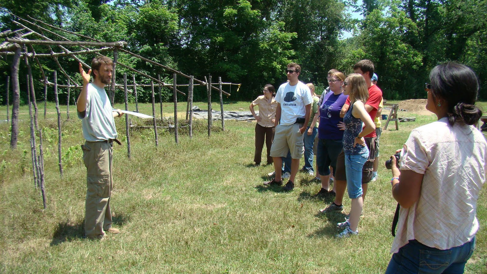
Yesterday, after laying out our units and mapping in the corner points, we started mapping out our surface artifacts on a drawn-to-scale grid. This morning, we finished that process and then proceeded to discover the joys of . . .
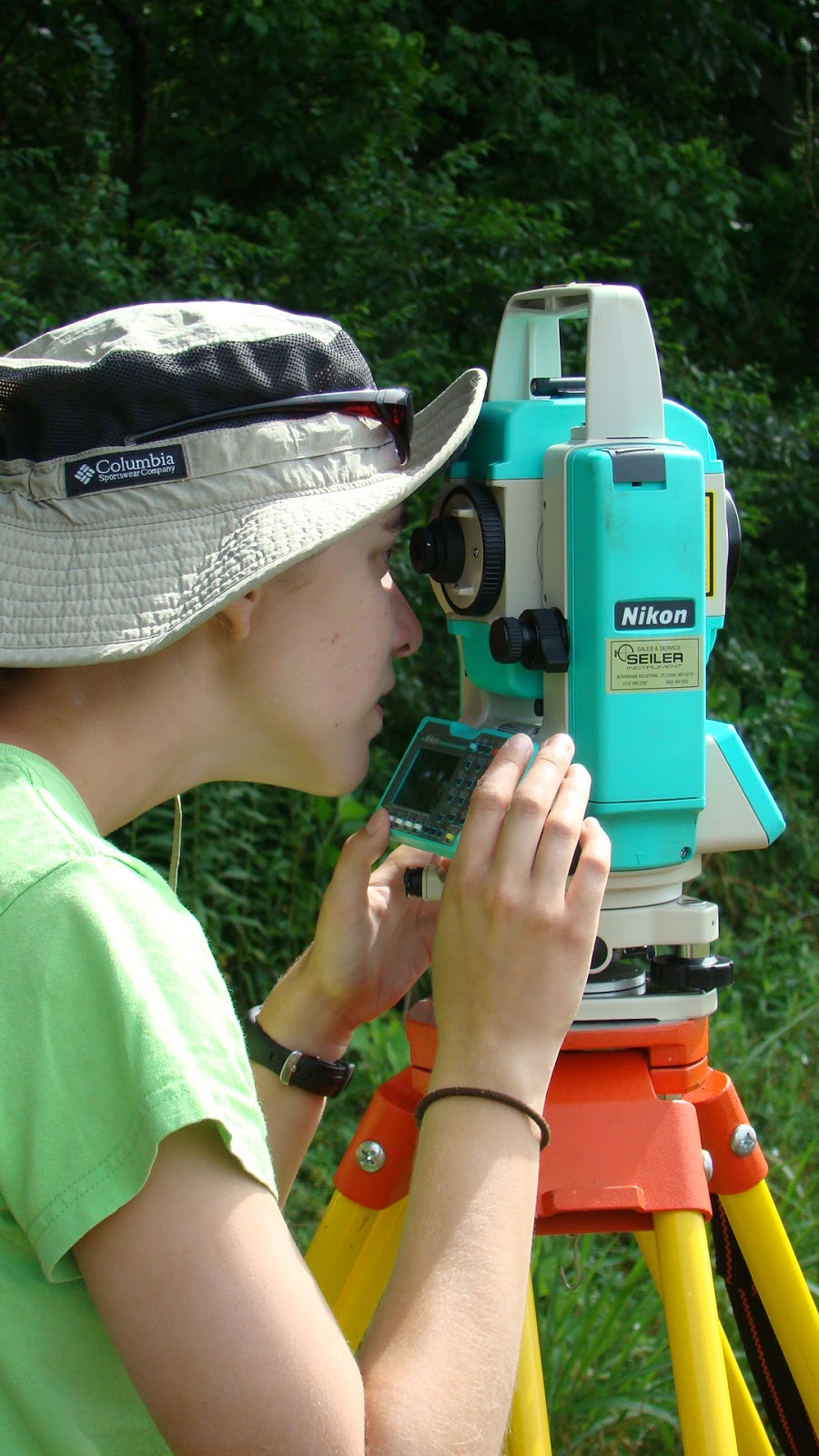
 paperwork.


But first, surface collection inside a unit: After we recorded our unit’s relative locations via a Total Station , we began a crawl survey inside the unit boundaries. Each piece of bone, shell, ceramic or lithic sitting on the visible surface was marked on a drawn-to scale map. Since our units are exact two meter squares, we can easily map the artifact’s location by measuring its distance to a vertical and horizontal edge of the unit.


After we were satisfied that everything visible was found (there are many artifacts on the surface, but hidden by grass or straw), we began the tedious but incredibly necessary process of paperwork. In our field journals, we began a list of lot numbers and artifact numbers. Along with basic location information, such as where we are working, what unit we’re working on, and what level we’re on in that unit, we also record any possible information that may be of use to future archaeologists. We don’t want another student fifty years from now puzzling over where a particular ceramic was recovered (because it’s often complicated)!


Such information includes the date, the size of the unit we’re working on (2x2 m), and the context or description of the lot (such as surface collection, plow zone, level one, etc.). We also record the soil type (such as silt, clay, sand, or some type of loamy mix of the any two or all three) and color (matched to a good old Munsell color chart) and a basic list of what we found (ceramics, lithics, bone, etc.).


Each ceramics or lithic we recovered on the surface was also given an ‘artifact number’ and description in the lot list, and was then bagged separately; bone and shell were bagged in groups together, and not given artifact numbers. Each bag requires its own separate tag with all the pertinent information recorded on it before being placed in a ‘master bag’ for that level, which also has its own tag; this is a purposefully redundant system that ensures that, under practically no circumstances will the provenience of the artifact be lost.


After the paper work stage (which took a couple hours), each group took corner and center elevations of their unit. To record the elevations, you first find the highest corner point; then, using a level and a long string attached to the corner pin, you can find the difference in elevation at the other corners. These are important for understanding the stratigraphy of the unit as you dig.


The next step is cleaning the unit before you begin digging. Cleaning a unit involves cutting – NOT pulling! – any grass, brushing back any loose straw, and generally making the dirt surface visible. A lot more surface artifacts were recovered during this stage, but since they weren’t previously visible in the crawl survey, they were just put together in the master bag.


Finally, after a unit is cleared, it’s time to begin the first excavations. We use flat shovels to shave off the dirt a few centimeters at a time. Since our first level is an arbitrary level of 10 cm, we’re not concerned with keeping the contours of the surface – this is because the field has been plowed, and most units have tire treds or plow lines running through them. These are artificial changes to the soil stratigraphy, and so we don’t follow them.


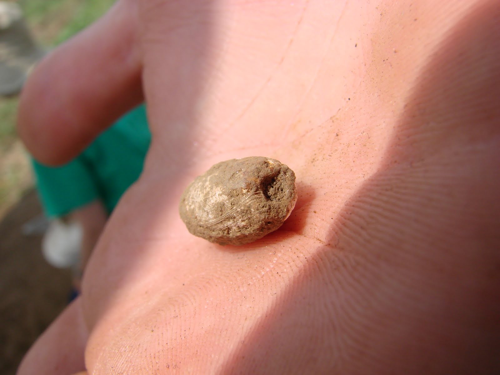
The loose dirt is then collected in our trusty Best Friend, Mr. Bucket, and then carried over to our sifters. Sifting allows us to pick out artifacts from the loose dirt that we missed while digging.


Artifacts recovered include things like shell, bone, ceramics, lithics and tiny beads - like above! We only had a little time to dig before our Field Director, Dr. Sampeck, called it a day – but it was great to finally start the excavations!


Cailin Meyer (ISU: Historical Archaeology Graduate Student)

Tuesday, June 7, 2011

June 7: Mini-video--meet Diana Fuller

June 6: Monday, Monday

Our return to work this week involved finishing plotting the site grid and refining the definition of the site. We had a minor equipment failure when the battery ran out for the total station. While the battery charged, the crew worked on better defining the south and east ends of the main settlement area. Crew members also delineated the outlying settlements in greater detail. The unusually high temperatures continued, but that did not deter the crew. We did, however, enjoy being in the cool recesses of the lab. Each student worked on establishing the topic for their Archaeology Day poster exhibit at the end of June at the Fairgrounds in Cherokee, North Carolina. Students also continued to classify the unanalyzed ceramics from previous fieldwork in the region.