Tuesday, June 4, 2013


Monday, June 3, 2013
May 31: Expect the Unexpected, by Bronwyn Schell
When
I told my friends that I was going to be working on an archaeological
dig this summer, one of them immediately asked, “What could you possibly
be digging for?” She seemed to be under the
impression, as I’ve found a lot of people are, that all artifacts and
discoveries one reads about in magazines or sees in museums or on TV are
found as they are, whole and complete, either in caves or churches, or
perhaps in temples out in the jungle, a la
Indiana Jones. While the truth may appear far less glamorous, and is
indeed much more work, it is also much more important scientifically,
and I’d argue, much more interesting!
Since
our dig has only just begun, finds are still fairly small, few, and far
between. However, that does not give us an excuse to be anything less
than exact in our work! Having done initial
survey out in the field across the narrow access road from our sites,
we moved on to the job of choosing our plots, clearing the ground, and
laying out our squares for excavating. This takes more than it sounds,
involving several people, a machete, a weed-wacker,
several shovels, and hours of work.

Now
that our plots are exactly laid out and marked, we began digging. After
clearing the initial weed-filled uneven sod, we find the highest corner
of our plot to mark as the ‘datum’, the location
from which the depths of all other points are measured. The goal is to
dig down in even, 10cm layers, so that the location of all finds and
points of interest can be accurately recorded in our field journals.
Even with two people working on each plot, work
is fairly slow going. If you’re trying to make a 2 meter square plot
exactly 10cm deep at all points, you can’t just dig in with a shovel! It
takes us at least a day to go down a layer, measuring constantly and
digging carefully and often by hand, trying to
remove intruding roots without disturbing the layer beneath. The layer a
find is discovered in can tell us what time the artifact ended up in
the ground, because objects further down are usually older than those deposited
on top. Once you reach the bottom of a layer,
it is time for celebration!

It’s
not as simple as just digging a hole, though. Even working with trowels
and by hand, plenty of valuable artifacts slip
through in the removed dirt. To make sure we don’t miss a single thing,
we first save every single shovel and handful of dirt, in buckets, on a
tarp, or in a wheelbarrow, and first sift it all through a 1/4 inch
screen by hand, removing larger roots and rocks
and checking for medium sized artifacts.

After
this, we’re still not done with the dirt! We save it in the wheelbarrows and
buckets until we have collected a decent amount,
then we take it down closer to the handily located river, where a large
hose and a pump bring up a steady, pressurized stream of water. In a
process called ‘water screening’, we carefully put each shovelful of
dirt through a second
windowmesh screen on sawhorses, letting the loose dirt run through and keeping anything
that doesn’t filter out. We put whatever is left in the screen in labeled bags, to be carefully hand-checked later in the lab.

Although
water screening is a very necessary part of archaeological excavation,
sometimes it’s a little difficult. You have to be careful, or you’ll
look like you’ve just gone in swimming!
When
not digging, eating, or sleeping, we go on field trips to sites of
cultural relevance and importance. For example, this week we went to
Cherokee, North Carolina to visit the Museum of the Cherokee Indian and
a living history park, Oconaluftee Village, to attain a better idea of the origin, history,
importance, and creation of the artifacts we are looking for and
researching.
Of course, occasionally we run into things we didn’t expect!

May 30: Signs of Life, by Nolan Russert
And so it began, another beautiful day in the Tennessee backcountry
at archeological site 40WG11. The temperature has been fairly mild for
late May, but today was one of the warmest we have had so far. The day
began with each team continuing to dig further in the soil hopefully to
uncover more artifacts.

Most teams were on their second and third levels, which is approximately 20-30cm below the present-day surface. All of the excavation pits are located on the north and northeast side of the cornfield, not far from the swift-moving Nolichucky River. The backdirt piles began to accumulate as we reomoved more and more earth. The main process that occurred today after removing all of the soil was water screening. The soil is put into a windowscreen mesh, and a water pump pulls water from the river to wash the soil. The soil is placed in the screen and through the process of continual water movement and the students' pushing it through with their hands, the loose soil is washed away, leaving behind artifacts caught in the screen. Today, we discovered many pottery sherds. As we dig deeper and continue to water screen hopefully more artifacts are found to give us further knowledge of Spanish contact in east Tennessee!

Most teams were on their second and third levels, which is approximately 20-30cm below the present-day surface. All of the excavation pits are located on the north and northeast side of the cornfield, not far from the swift-moving Nolichucky River. The backdirt piles began to accumulate as we reomoved more and more earth. The main process that occurred today after removing all of the soil was water screening. The soil is put into a windowscreen mesh, and a water pump pulls water from the river to wash the soil. The soil is placed in the screen and through the process of continual water movement and the students' pushing it through with their hands, the loose soil is washed away, leaving behind artifacts caught in the screen. Today, we discovered many pottery sherds. As we dig deeper and continue to water screen hopefully more artifacts are found to give us further knowledge of Spanish contact in east Tennessee!
Thursday, May 30, 2013
May 22: You Got to Flag ‘em to Bag ‘em, by Daniel Scott
After an evening filled with rain we arrived at our new
field site with childlike enthusiasm. The owner of the field had just recently
plowed and planted this season’s corn making our systematic survey easier – as
the recently plowed ground clearly exposed ceramic sherds, lithics, bone,
shells, and fire cracked rock. With conditions right we spaced ourselves –
three corn rows dividing each individual – and began the process of slowly
walking North East through field marking the beginning and ending of “hot spots”
(which provide invaluable information as to the manner in which the town was
organized while also guiding us to the best location where we might place our
units and begin excavation). The previously mentioned surveying conditions
along with the relatively flat field allowed us to locate, identify, and
finally flag artifacts with ease, with the only hiccup in the day coming when
all the flags were expended.


Upon the completion of the flagging process – the following
day – the epicenter of the site revealed itself to be the most level ground on
very east of the field, nearest to the Nolichucky River – a common location as discovered
through previous field projects in the region – while smaller scatters of artifacts
were found outside this main concentration.

Once the flagging process was completed we began to collect
the artifacts by way of dog leashes. This method is executed by placing one’s
self in a group of flags and collecting everything within a five meter radius
of their center – we began at the south western tip working our way across the
field, avoiding isolated finds as often as possible. The center of each dog
leash circle was given a designated number, flagged, and plotted on a map
sketch of the area in order to keep the integrity of the town’s organization.
The vast area along with the large amount of findings prohibit a swift
completion of the gathering of all artifacts. Scenarios such as these are often
conducive to looters, however, our daily presence at the site along with the benefit
of its location on private property has allowed us to avoid becoming another
chapter in the long book of looted archaeological sites.
Prior to the onset of the Iraq war in 2003 archeologists in
the area and throughout the Middle East were brought home without the ability
to clean up or finish that season’s work. Martin Gottlieb’s article in the New York Times on June 12, 2003 quoted
the University of Chicago Dr. Gibson as he described the aftermath of the
looting of several active archaeological sites as a “devastated landscape” which
resembled “Swiss cheese” due to the deep holes dug by looters. This example is
just one of the many challenges that archaeologists face during a successful
and prolonged dig. [1]

Figure 1.
Aerial view of the devastated site of Umma, southern Iraq, in September 2003.
Looter pits eclipse scientifically excavated areas identifiable by walls and
mounds of spoil in their immediate proximity. Courtesy of Comando Carabinieri
Tutela Patrimonio Culturale.[2]
[1]
Martin Gottlieb, Looters Swarm Over Remote Sites, Study Finds, New York Times, June 12, 2003: http://www.nytimes.com/2003/06/12/world/after-the-war-antiquities-looters-swarm-over-remote-sites-study-finds.html
[2]
Kathryn Tubb, Irreconcilable Differences? Problems with Unprovenanced Antiquities,
Papers from the Institute of Archaeology,
Vol. 18 (2007): http://pia-journal.co.uk/rt/printerFriendly/pia.294/390
Tuesday, May 28, 2013
May 27: A little work, a little celebrating on Memorial Day
Our very ambitious plans for research goals this summer do not allow for much time off. We started Monday morning bright and early with more systematic survey work at 40WG11.

After the initial survey of the fields completed last week, we began systematic collections of the artifacts visible on the surface. The locations of these collections will be plotted on the site map and the artifacts will be analyzed to look for patterning in the number and kind of artifacts in different sections of the settlement.
Towards the end of the day, we also selected the location of excavation units. The excavations are located in a vulnerable area of the site, where the Nolichucky River has flooded sometime in the distant past and washed away an unknown amount of the settlement. The units are located near this area that has the potential to be further damaged by river flooding.
After this very busy day, we got together for a barbeque. The Field Director, Beau Carroll, was also the master of the grill and campfire:
 We enjoyed a delicious dinner together and were glad to have a little time to reflect upon the service, sacrifice, and commitment of all those who have served our country.


After the initial survey of the fields completed last week, we began systematic collections of the artifacts visible on the surface. The locations of these collections will be plotted on the site map and the artifacts will be analyzed to look for patterning in the number and kind of artifacts in different sections of the settlement.
Towards the end of the day, we also selected the location of excavation units. The excavations are located in a vulnerable area of the site, where the Nolichucky River has flooded sometime in the distant past and washed away an unknown amount of the settlement. The units are located near this area that has the potential to be further damaged by river flooding.
After this very busy day, we got together for a barbeque. The Field Director, Beau Carroll, was also the master of the grill and campfire:


May 20-26: A busy week to start the fieldwork!
The 2013 field school had a great beginning. Usually we spend the first day getting oriented to lab procedures and the archaeological collections. This year, we set off to do survey work, as well. We began by surveying 40GN13, site recorded in Greene County. The field is currently being used as a pasture and was covered in buttercups. Because the visibility of the ground surface was difficult because of the dense vegetation, students used a small auger to take column soil samples to see if we could recover evidence of human occupation

We placed these auger tests in an even spacing of every 15 meters and had tested most of the hillside by Tuesday. The clay was tough and it was a challenge to get each sample! We recovered several pieces of chert flakes and carefully chipped tools.
On Wednesday, we began surveying in a very different setting: a plowed cornfield, the location of 40WG11, a site recorded in Washington County. As you can see in the photo, the corn plants were very small.

The survey conditions were excellent due to recent plowing and recent rains. The rain, in fact, prevented us from going to the field on Thursday morning, and when we ventured out to the site to work, the ISU van got stuck in the mud. I am glad to say that we extracted the van through a great team effort.


We placed these auger tests in an even spacing of every 15 meters and had tested most of the hillside by Tuesday. The clay was tough and it was a challenge to get each sample! We recovered several pieces of chert flakes and carefully chipped tools.
On Wednesday, we began surveying in a very different setting: a plowed cornfield, the location of 40WG11, a site recorded in Washington County. As you can see in the photo, the corn plants were very small.

The survey conditions were excellent due to recent plowing and recent rains. The rain, in fact, prevented us from going to the field on Thursday morning, and when we ventured out to the site to work, the ISU van got stuck in the mud. I am glad to say that we extracted the van through a great team effort.

Thursday, March 21, 2013

Thursday, June 30, 2011
Our Intrepid 2011 Field School Crew!

From left to right: Lorelei, Andrew, Diana, Cat, Dave, Valerie, Neil, Steve, Nick, Laura, Helen, and Dr. Sampeck.
Wednesday, June 29, 2011
Features!
At the start of the day some of the units were already down to the natural soil layer, while others still had to keep digging to get down to theirs due to there being more sediment from flooding over the years. Those of us that were already down to the natural soil began our day in the field by defining our features and mapping them to scale on graph paper. After we finished that we got to start carefully digging up our features and bagging up the dirt for flotation to recover small things like organic material.
Below: Steve Scheflow digging up a post mold and bagging the dirt

Since we were digging much smaller areas and had to be careful not to damage artifacts and to keep the integrity of the shape of the feature we ditched our trowels and started using spoons and dental tools.
Below: Laura Volz works on exposing a pottery sherd with a dental pic

Some of our features had nothing in them, some had a few artifacts, while others (like the above photo) had an abundance of artifacts, including shell (marine & freshwater), pottery sherds, chert, bone and a bone bead. For the features that contain many artifacts we had to dig around them and leave them where were naturally deposited (in situ) in order to see the way they are arranged to help us possibly figure out why they are positioned the way they are. Then once the exposed artifacts have been photographed in situ they can be collected.
Below: Two post molds and a feature with half of the artifacts in situ

As we continue to excavate our units these last two day we hope to find more exciting things in our features that can help give us a better look at the people that once lived on this land we've been digging in.
Sunday, June 26, 2011
Saturday, June 25, 2011
A day in the sun, finally.
Yesterday morning was filled with thunderstorms, however after waiting for an hour and a half they quickly passed and it turned into a bright sunny day around 8:30 AM. The weather was perfect really, because it dried out the units (those that weren't flooded anyway) and it was only 80 degrees outside, so not too hot.
We got to the field later than usual because of the storms and once there we got to work on either excavating our units or on bailing water out of the flooded units. Afterwards, some units started water screening their dirt right away because it was too wet to dry sift through. Other groups went on like usual.
I started on my third level yesterday and I'm already seeing a difference in my collection of artifacts. The pieces of pottery I'm finding are more often decorated and larger. I'm also finding more complete projectile points and larger pieces of bone too.
When we got back to the cabins we had lab on our own time so that we all could complete our posters. My project is on Cherokee dances. I talk briefly about the origin of Cherokee songs and dances and give examples of some dances too. I also talk about the evidence we have for dancing at our site. We have been able to define an area with a significant lack of artifacts compared to the areas around it that has a circular shape. This was most likely the plaza, where most of the dances would have taken place. We're also finding a large number of turtle shell, especially in the northern units. Many Cherokee dances included turtle shell leg-rattles that were filled with rocks to create music. A lot of this shell was probably used for those dances.
Next week will be our last week here and so we'll continue excavating for a few days and then begin to fill up our units and whatever else necessary to clean up. We also will be presenting our poster presentations on Tuesday so next week should be very busy.
Thursday, June 23, 2011
June 23: Guests of Honor
The day had a dismal start--rain and more rain. We went to the site, hoping the rain would break, and eventually it did. The ground was already saturated from the rain during the past few days, so we continued making dog leash surface collections.
The morning's work brought us close to finishing comprehensive surface collections of the whole settlement area. It is really striking how much the plants have grown since we began the survey. If we did not have the flags from the first week's work, some artifacts would never have been found again!
![]()
 |
| David Watt and Laura Volz outfitted for rain |
 |
| Valerie Hall discovered this ceramic pipe on the surface at the east end of the site |
 |
| Lorelei Schak peers into the ground cover to look for artifacts |
 |
| Cailin Meyer uses her awesome red bag to carry tools of the trade |
 |
| Bo excavates a plow scar filled with food remains |
Later that morning, the threat of rain had subsided, so we opened up the excavation units once again. We had some special guests--archaeologists from the Tribal Historic Preservation Office of the Eastern Band of Cherokee Indians. Yolanda Saunooke, the Section 106 assistant, and an intern, Bo, arrived at just the right time--we were wrapping up with collections. After a site tour, Bo pitched in with the excavations. Some units were filled with water again, but others were damp but not overly muddy. Bo was impressed with the soft soil and the abundant artifacts.
 |
| Yolanda Saunooke oversees excavations |
We had a longer field day to take advantage of the dry weather and the excellent company. We found well preserved animal bone and large chunks of charcoal. The students with water filled units pitched in with excavations in drier units and with water screening. In all, it was a great day!

June 21: Hump Day
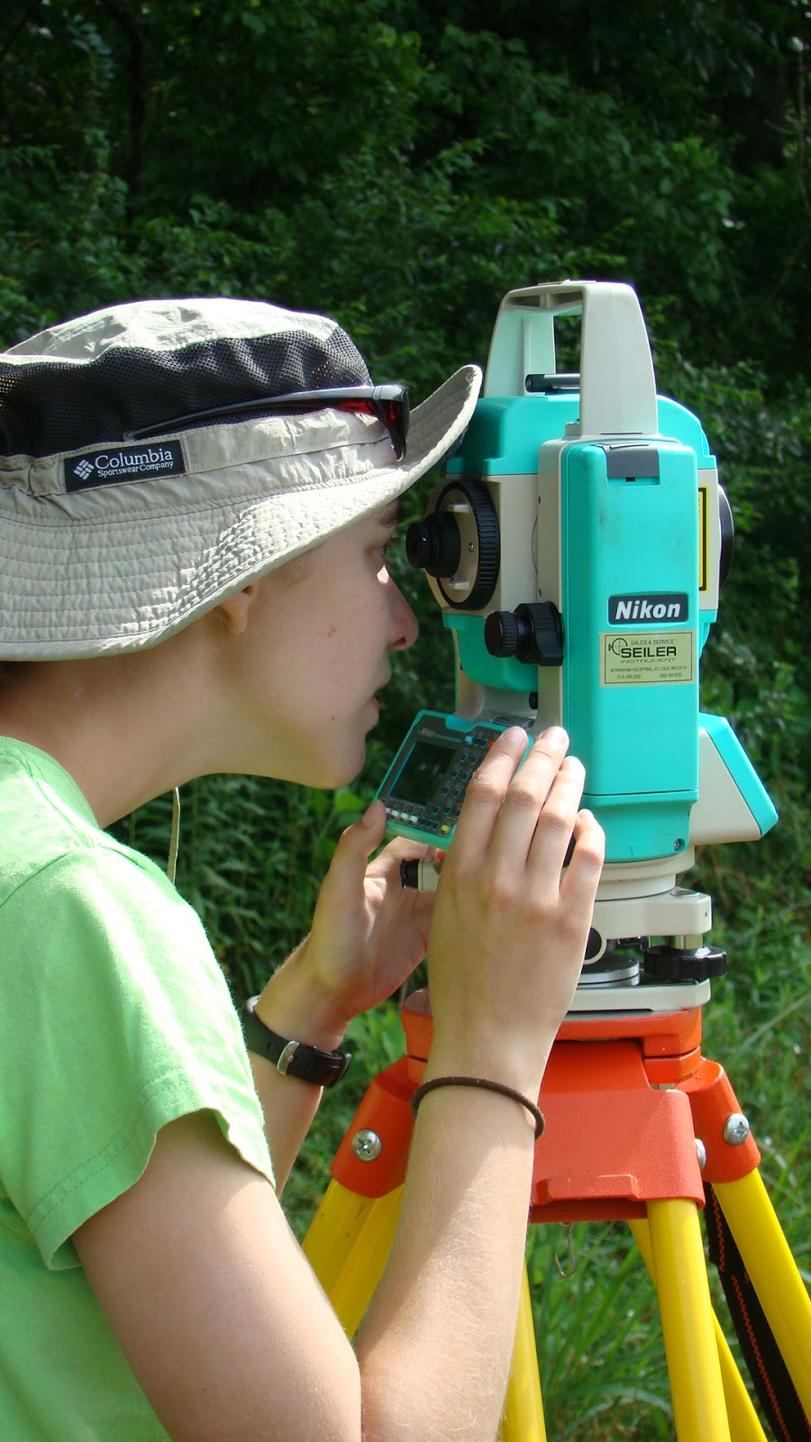 |
| Helen Brandt plots map points using the Total Station |
Another rainy day kept us from returning to excavations until the very end of the day. Most students continued making dog leash collections and Helen Brandt and Andrew Border were the mapping team.
 |
| Andrew Border holds the prism for mapping |
 |
| A Dog Leash Collection |

Wednesday, June 22, 2011
June 21: Joara Chronicles
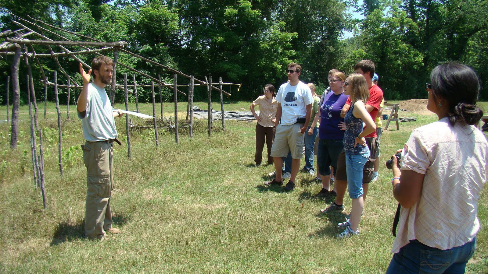
One of the best ways to understand a site is to put it in context. Our trip to the Berry site, near Morganton, North Carolina showed us the broader picture of Native American-Spanish colonist interactions in the region. Project directors Chris Rodning (Tulane University) and David Moore (Warren Wilson College) explained the archaeological methodology they have used over the last decade or so to determine that the Berry Site was almost certainly Fort San Juan, built by Juan Pardo in the 1560s. The Spanish fort was built at the prosperous Native American (possibly Catawba) town of Joara. Joara is mentioned in both the de Soto and Pardo chronicles, and the archaeological evidence supports the existence of a town here from the 1540s through the end of the sixteenth century.
 |
| Laura Volz holds a steatite tempered sherd |
 |
| David Moore shows us a ceramic bead |
A great find excavators recovered while we were there was a ceramic bead. We have found several shell and bone beads, but we have not yet found a ceramic bead of this type.
 |
| David Moore points out a feature |
Both Moore and Rodning showed us the details of their excavation procedures and the architectural and other features they have discovered this season. They have found evidence of several large and small pit features that may relate to early colonial constructions at the site, including borrow pits for recovering clay for making structure walls. These shallow, wide pits were later filled in with garbage.
 |
| a small pit filled with burnt corncobs |
 |
| Chris Rodning has a few parting words for the students |
June 20: Rainy Days and Mondays
On Monday morning we all awoke to the sound of loud rumbling thunder instead of the seemingly usual 90 degree-plus heat. While the weather kept us from going out to the field in the morning it eventually cleared up in the afternoon enough for Dr. Sampeck to take a few students out to work on some mapping and surface collections. While in the field, this group worked in areas previously mapped and collected artifacts on the surface for cataloging. They also mapped other clusters of artifacts using the total station for future collection.
The remaining students who did not venture to the field returned to the lab after lunch to continuing working on our individual poster projects or cataloging artifacts. Having the whole morning--and for some all day--to work on our posters was a wonderful surprise. I was able to analyze the projectile point data that I have been collecting. I was also able to work on identifying what kinds of points that I have been working with. While working with the points I have been able to identify multiple point styles as well as an average data range. The others in the lab were also examining or cataloging artifacts.
The remaining students who did not venture to the field returned to the lab after lunch to continuing working on our individual poster projects or cataloging artifacts. Having the whole morning--and for some all day--to work on our posters was a wonderful surprise. I was able to analyze the projectile point data that I have been collecting. I was also able to work on identifying what kinds of points that I have been working with. While working with the points I have been able to identify multiple point styles as well as an average data range. The others in the lab were also examining or cataloging artifacts.
 |
| a possible Madison Point |
While I assume that everyone was disappointed in missing a day out on the dig it was a pretty successful day. As a group we were all able to make significant strides on our projects and the contingency that went to the field were able to help keep pace with surface collecting and mapping the site.
 |
| I have not been able to idenitfy this point |
written by Steve Scheflow
Sunday, June 19, 2011
June 18: A mapping weekend
 |
| The Nolichucky River |
The 9AM-5PM corporate grind goes not exist here in Tennessee. No, the work must continue....Saturday a few of us went back to the site to water-screen and continued to surveying the site.
We are using a Total Station to map the site. The Total Station is a sophisticated survey equipment used to precisely plot points for the map. This equipment is nice because it calculates distance relative to the datum, placing the point within the horizontal-vertical axis. Yes, there is more to archaeology than digging!
![]()

The purpose of archaeological survey is to understand the spatial pattern of the site by making a map of the topography and artifact distributions. This mapping creates a record of the relationship between cultural features and significant environmental factors. It is important to accurately relate archaeological sites to natural or cultural landmarks in order to accurately record changes in the topography.
We toiled for a few hours only to retreat back to our cabins fleeing from an approaching storm. Farewell my comrades in archaeology!
- Andrew
Subscribe to:
Posts (Atom)