 This year, the field school dates are May 30 to July 1. Please join us! You can email inquiries to ksampec@ilstu.edu
Showing posts with label historical archaeology. Show all posts
Showing posts with label historical archaeology. Show all posts
Friday, February 4, 2011
2011 Field School Information
This year, the field school dates are May 30 to July 1. Please join us! You can email inquiries to ksampec@ilstu.edu

Sunday, June 20, 2010
Day 15 - Visiting the Berry site
On Friday we visited the Berry site, a long term archaeological research site near Morganton, North Carolina. The current project is co-directed by Dr. Christopher Rodning of Tulane University in New Orleans and Dr. David Moore of Warren Wilson College.
Dr. Rodning was kind enough to give us a tour and explain the significance of the site. A large Native American town was located at the site from 1400 to 1600 A.D. Archaeological investigation at the Berry site focuses on the Spanish contact period, when the town was known as Joara, and visited by Hernando de Soto in 1540, and Juan Pardo 30 years later. A fort was built at the site by Pardo in 1567 and lasted for 18 months before it was abandoned due to conflict with the Native people.
The Berry project is impressive in both its large scale and its community atmosphere. There were at least a dozen people working, and they ranged in age from 18 to 50. They worked as a harmonious team, with some shovel skimming the surface of units, while others were sifting the earth through screens, carting the dirt away in wheelbarrows and washing artifacts. They took their morning break during our visit, and distributed popsicles and ice cream sandwiches to all workers and guests as a cool treat to beat the heat.

As our group looks on, Dr. Rodning climbed up a latter to photograph large features from above.

Our group was able to examine the recently unearthed and washed artifacts as they dried in the screens.
Following our visit to the Berry site we stopped for lunch and then traveled back to Tennessee to continue our work.
Dr. Rodning was kind enough to give us a tour and explain the significance of the site. A large Native American town was located at the site from 1400 to 1600 A.D. Archaeological investigation at the Berry site focuses on the Spanish contact period, when the town was known as Joara, and visited by Hernando de Soto in 1540, and Juan Pardo 30 years later. A fort was built at the site by Pardo in 1567 and lasted for 18 months before it was abandoned due to conflict with the Native people.
The Berry project is impressive in both its large scale and its community atmosphere. There were at least a dozen people working, and they ranged in age from 18 to 50. They worked as a harmonious team, with some shovel skimming the surface of units, while others were sifting the earth through screens, carting the dirt away in wheelbarrows and washing artifacts. They took their morning break during our visit, and distributed popsicles and ice cream sandwiches to all workers and guests as a cool treat to beat the heat.

As our group looks on, Dr. Rodning climbed up a latter to photograph large features from above.

Our group was able to examine the recently unearthed and washed artifacts as they dried in the screens.
Following our visit to the Berry site we stopped for lunch and then traveled back to Tennessee to continue our work.
Monday, June 7, 2010
Day 5 - Cherokee, North Carolina

By Project Director, Dr. Kathryn Sampeck
We ended our week of learning about the landscape by traveling to Cherokee, North Carolina to meet with the Eastern Band of the Cherokee Indians (ECBI) Tribal Historic Preservation officers and to explore different museums in Cherokee. Our project has strong ties with the ECBI and benefits from active collaboration and participation of members of the ECBI.
The route from Greeneville, Tennessee to Cherokee features has stunning scenery in the Appalachian Mountains, passing through the Cherokee National Forest and the Pisgah National Forest. Even today’s highways have to negotiate steep twists and bends before descending into the Asheville Basin. Nevertheless, the early historic material culture from Washington and Greene Counties show strong similarities to these parts of today’s North Carolina, so these mountains were not an impassable barrier in the past.
We started our visit with a tour of the sacred site of Kituwah. ECBI archaeologist Russ Townsend explained that all Cherokee regard Kituwah as the mother place, where the first Cherokee council fire burned and that Kituwah has always been important in Cherokee life. ECBI historian Tyler Howe and archaeologist Yolanda Saunooke showed field school students different parts of the site, including the medicine place near the Tuckasegee River.
We next visited the living history museum of the Oconaluftee village. There we saw craftworkers producing traditional Cherokee material culture, including projectile points, wood carvings, baskets, and belts. Guides explained Cherokee political and social organization in detail as part of their tour. In the mid-afternoon, we attended a demonstration of several social dances in the village dance grounds. Ocunaluftee has model homes typical of different time periods, allowing us to see changes in architecture from the 1540s to the nineteenth century. Being able to step inside a sweat lodge or an 1830s house gives us a better sense of archaeological traces of the past.

Potter's tools from Oconauftee include a paddle for decorative marking and shells for incising and scraping.
After the village, we ended our visiting day in the Museum of the Cherokee Indian. Exhibits cover each major period of Cherokee history, from the earliest Paleoindians and their stone tools to Cherokee soldiers in World War II. The museum is notable for its detailed presentation of the historic period, especially the eighteenth and nineteenth centuries. This week the students have been studying Mooney’s Myths of the Cherokee, and a number of narratives collected in that work were vividly depicted and recounted at the museum. Regarding material culture, whole ceramic vessels. much like the small fragments we are studying in the project lab, were on display, as well as more recent pieces. The whole day gave us many perspectives on the place, history, and peoples we are studying.
 Early spear points
Printed in the Cherokee script
We returned to Tennessee on a different route, this time through the Great Smoky Mountains National Park. Rain soon drenched the roads and forests, but after a short while the sky brightened and a shimmering rainbow shone before us, the perfect end to our day.

Wednesday, June 2, 2010
Day 3 -- Survey of Washington County
By Project Director, Dr. Kathryn Sampeck

Moving out of our home base and environs, today we broadened horizons and explored the numerous historical sites of Washington County, Tennessee. In comparison with the parts of Greene County we visited yesterday, we could appreciate some of the unique features of early historic settlement in Washington County. One of these is the abundance of rich soils near the Nolichucky River. Cherokee towns in Washington County often were situated in pairs, one on each side of the river, a pattern not seen in Greene County, where fertile river plains on one side often face steep bluffs on the other shore. These paired villages in Washington County may have had a distinctly different sociopolitical dynamic because they could see each across the river.
 The Nolichucky River
We have to remember that the more recent sociopolitical division of Washington and Greene Counties should not overshadow our interpretations of the past. We also noted that today's county divisions perhaps encourage us to think that areas were divided, but we could see that some areas between Washington and Greene County were easily accessible by the old road system. We noticed that in general, Washington County had more early historic Cherokee towns (after contact with Europeans) that were fairly regularly spaced along the Nolichucky River, and a few other early historic Cherokee towns near smaller creeks such as Little Limestone Creek.

One of the most distinct settlements in the region is found in Washington County, on National Forest Service land at the edge of the Cherokee National Forest. One of the largest Cherokee towns in eastern Tennessee was located near Jackson Island. Archaeological excavations conducted in the 1970s revealed Spanish goods and extensive settlement. Also, the site was probably occupied earlier than many of the Cherokee towns in the region, judging from the presence of artifacts not in use after European contact.
This area was also one of the first homes of John Sevier, the first governor of Tennessee. Overgrown with trumpet vines, tickweed, and river cane, the chimney of his house look for all the world like an ancient jungle ruin, less preserved than persisting. While visiting the grounds, we found on the road surface, and left according to federal regulations, a fragment of a 19th century stoneware vessel, possibly a product of the nearby Decker pottery. The Sevier house is located on a hill with a dramatic view of the river plain.
 Federal warning about damaging the site or removing materials
 20th century stairs leading to the 18th century ruins of the John Sevier House

 Examining the chimney
 19th century stoneware found, and replaced, on the surface of the road.
This may have come from a Decker vessel.
After visiting nearly a dozen archaeological sites in Washington County, we stopped and enjoyed (literally) the fruits of the land, on sale at a local farmers' market.


After these two days of focus site survey, we can appreciate the special place in Cherokee history of the site we will begin mapping and excavating over the coming weeks, the Yellow House Site.

Moving out of our home base and environs, today we broadened horizons and explored the numerous historical sites of Washington County, Tennessee. In comparison with the parts of Greene County we visited yesterday, we could appreciate some of the unique features of early historic settlement in Washington County. One of these is the abundance of rich soils near the Nolichucky River. Cherokee towns in Washington County often were situated in pairs, one on each side of the river, a pattern not seen in Greene County, where fertile river plains on one side often face steep bluffs on the other shore. These paired villages in Washington County may have had a distinctly different sociopolitical dynamic because they could see each across the river.
 The Nolichucky River
We have to remember that the more recent sociopolitical division of Washington and Greene Counties should not overshadow our interpretations of the past. We also noted that today's county divisions perhaps encourage us to think that areas were divided, but we could see that some areas between Washington and Greene County were easily accessible by the old road system. We noticed that in general, Washington County had more early historic Cherokee towns (after contact with Europeans) that were fairly regularly spaced along the Nolichucky River, and a few other early historic Cherokee towns near smaller creeks such as Little Limestone Creek.

One of the most distinct settlements in the region is found in Washington County, on National Forest Service land at the edge of the Cherokee National Forest. One of the largest Cherokee towns in eastern Tennessee was located near Jackson Island. Archaeological excavations conducted in the 1970s revealed Spanish goods and extensive settlement. Also, the site was probably occupied earlier than many of the Cherokee towns in the region, judging from the presence of artifacts not in use after European contact.
This area was also one of the first homes of John Sevier, the first governor of Tennessee. Overgrown with trumpet vines, tickweed, and river cane, the chimney of his house look for all the world like an ancient jungle ruin, less preserved than persisting. While visiting the grounds, we found on the road surface, and left according to federal regulations, a fragment of a 19th century stoneware vessel, possibly a product of the nearby Decker pottery. The Sevier house is located on a hill with a dramatic view of the river plain.
 Federal warning about damaging the site or removing materials
 20th century stairs leading to the 18th century ruins of the John Sevier House
 Examining the chimney
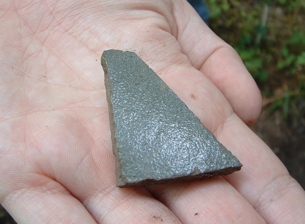 19th century stoneware found, and replaced, on the surface of the road.
This may have come from a Decker vessel.
After visiting nearly a dozen archaeological sites in Washington County, we stopped and enjoyed (literally) the fruits of the land, on sale at a local farmers' market.


After these two days of focus site survey, we can appreciate the special place in Cherokee history of the site we will begin mapping and excavating over the coming weeks, the Yellow House Site.
Subscribe to:
Posts (Atom)